
Oh, you can download these tiny images if you like, but the original image is 440 Megapixels and accessible only via a special viewer like that used for Google Earth. It is a 160° panorama of Golden Gate Park and the Bridge. The host site, Gigapan.org has a collection of gigapixel and near-gigapixel images, created with a new robotic tripod, your digital camera, and special software to stitch together a few hundred images. This is not an ad for the machine, so I'll let you link to it from the Gigapan.org web site if you like.
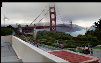 Of more interest to me as a photographer, is the actual blow-my-mind detail in a gigapixel image. For starters, click on the panorama above to see a 1 megapixel image, with one-440th of the detail. This snippet to the left is not much of an enlargement, but we're just getting going.
There is a walkway below center, with people on their way to or from the pedestrian lane of the bridge.
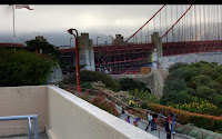 Zooming just 2x, we can see the nearby section of the walkway, but the farther section, near one of the bridge abutments, is still not so clear.
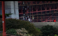 Zoom a further 3x, and you can begin to see people on the far section of the walkway: a small group at the center, and someone in a red jacket to the right.
 A further zoom by 4x (this is a total of nearly 30x) reveals four people with bicycles. The image you see when you click here is pretty close to full resolution. Its size is 667x415: 277 kilopixels, or 1/1600th of the entire image.
The process used to make these is to drive the camera, with its zoom lens all the way out, over a gridded pattern with some overlap from image to image. In this case there were five rows of 24 or 25 images each. A special stitcher program converts the array into one large image. The image capture process takes several minutes.
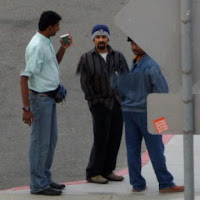 Like any multi-shot panorama, the Gigapan works best with stationary landscapes. Moving things like cars and people cause amusing anomalies. The stitch line between two rows runs through the middle of this clip. Take note of the direction the feet are pointing on the man on the right. He turned clear around between passes, while the other two men moved only slightly.
You would not want to print a gigapixel image. I don't think they make paper big enough. Photo printers produce prints with a resolution no better than 150 dpi (6 px/mm). A square gigapixel image is more than 30,000 pixels each direction, and would require a sheet 200x200 inches or larger (almost 17x17 feet, or 5x5 meters). No, the appropriate medium is a viewer to zoom and pan online, which is what Gigapan.org provides.
This also got me thinking, we've all been using a multi-gigapixel viewer for some time, in Google Earth, Google Maps, and similar products from Mapquest and Vicinity, and let us not forget Microsoft's Terra Server. Considered as a big image, how many gigapixels are in the Google Earth dateset? The calculation is hard, because the resolution varies from place to place. The base resolution is 1 meter, available over most of the land area of Earth. I don't know what the resolution is for the sea floor, so let's just figure out the 25% that is on land:
- Global radius is 6,370 km, or 6.37E6 meters.
- Global area is 4πr², or 5.1E14 square meters.
- Land area is one-quarter of this, or about 1.27E14 m².
- That is a 127,000 gigapixels, minimum, or 127 Tpx!


No comments:
Post a Comment